Tha Ton

Early morning mist in Tha Ton

From Chiang Mai we headed for the hills on a big orange bus. There were a few tourists on board but it was mainly used by locals travelling to the large town of Fang while a few up-country locals and one other westerner were travelling like us to its final destination of Tha Ton. Seats which we thought the right size for two were actually meant for three but we were lucky, or looked too big, and had one to ourselves. Those trying to fit three to a seat often ended up sitting on the edge of a seat or standing in the narrow walkway. Apart from that it was fine with open windows and fans to keep us cool and rural scenery to watch which kept us occupied through the four hour trip.

Tha Ton is a small country town near the border of Thailand and Burma (Myanmar) and is a huge change of pace from Chiang Mai. It has one main road and straddles the Kok River.  We stayed in a comfortable guest house beside the river for a couple nights and soon had our favourite places to visit for our meals and for coffee, revisiting a few of them several times. We loved the atmosphere of the town and the friendliness of the local people. It was a peaceful stay except for the evening Karaoke across the river from our guest house. Paul enjoyed the early morning mist for some atmospheric photography.

Worth a visit is Wat Tha Ton, a temple which stretches up the hill beside the town. It is set over ten levels and we huffed and puffed our way right up to the top. We had plenty of reasons to stop along the way to look at amazing buildings and the statues at various levels as well as the fabulous views to the valleys and river below. We could even see the Thai army emplacement on distant hill tops which looked out over the border with Myanmar. The many coloured temple at the top contained an eclectic collection of statues.

From Tha Ton we headed further into the hills and into the area previously known as the infamous Golden Triangle, the area near the borders of Thailand, Burma and Laos which used to be the major opium trafficking route but is now a great area for tea and coffee.


Malawi

Beachfront at Kachere Kastle, Lake Malawi

Malawi is a relatively small country, roughly 900km long and between 80km and 150km wide, in comparison with the others we have visited so far. Almost one fifth of the country is covered by the inland sea, Lake Malawi is the focal point for most visitors and there are also highlands in the north and the south which we want to visit. As well as Zambia, the country also has borders with Tanzania and Mozambique. Its a friendly, inexpensive and easy country to travel in so we plan to stay about five or six weeks.

We cross into Malawi from Zambia in the far north west at the tiny border post of Chitipa. The road from Zambia was very rough and slow for the last part of our trip and it is dark by the time we have cleared the border so we’re happy to find a guest house and take a room for the night. It’s basic but clean and has an ensuite and secure parking, pretty good for 5,000 Malawi Kwacha which is about $9.00 Aussie dollars.

In the morning we have an easy drive down from the high country to the town of Karonga on the shores of Lake Malawi. It’s quite a big town and has a bustling and colourful market where we can stock up on wonderful fresh produce.

Alfred and his wife Elizabeth and their three sons and three daughters have built and run Thunduzi Camp on the shores of Lake Malawi in the tiny settlement of Chilumba. The camp is very quiet but the attached bar and restaurant do a good trade and Alfred has plans to make more improvements to the camping and to add additional accommodation. It’s a very pleasant spot and we need a break from travelling so we are soon set up and settled in for the next couple of weeks. Unfortunately I have a bit of a virus and need to spend a fair bit of the first week sleeping and then slowly recuperating but Paul easily fills in his time with his photos and also taking a walk with one of Alfred’s sons through the village to visit the local ‘brewery’ and to meet some of the local people and sample some street food.

During the second week, when I am mostly recovered, we take a drive back up into the high country to the old mission station and colonial town of Livingstonia. To reach it we have a short drive down the main road next to the lake then a steep climb up an unmaintained dirt track. The last ten kilometres takes an hour and we are very glad we didn’t bring the trailer. The town was built on the edge of the plateau west of the lake by Scottish missionaries in the 1890’s because too many people were dying of malaria at the original mission settlements at the lower altitudes beside Lake Malawi. Livingstonia is picturesque with solid stone buildings spread along tree-lined streets and wonderful mountain views in all directions. It is also much cooler up here and it is pleasant to spend a couple of nights tucked under a cosy doona at the Lukwe Permaculture Camp. Paul walks through the permaculture gardens to the nearby Manchewe Falls but I’m content to sit and enjoy the views and complete my recuperation. Or maybe I was just feeling lazy.

After another couple of nights back at Thunduzi its time to move on and we head toward the Nyika Plateau National Park. We stop overnight in Rumphi on our way and find a place to leave our trailer as we are in for another steep drive. While Livingstonia, at 1200m above sea level, is more than 900 metres above the lake, Nyika Plateau is over 2,500m above sea level. Nights are much cooler, with a light dusting of frost on the grass in the mornings, so we need to dig out our cold weather clothing and add a down sleeping bag on top of the doona. Its worth it though with wonderful views and plenty of chances to spot wildlife. At this altitude there are not a lot of native trees, just the remains of a failed pine plantation in one section, and the hills are covered in rolling grassland punctuated by rocky outcrops. There are zebras, reedbucks, eland and other antelope scattered around the hills and pretty bushbucks hang around the camp ground and the lake by the lodge. Leopard have been sighted recently not too far from the lodge but although we try hard we aren’t lucky enough to see them. There are also elephant and buffalo in the park but at this time of the year they head to lower altitudes in a corner of the park which isn’t accessible by car.

After two and a half days spent driving through the glorious country and two nights huddling around the fire while we gaze at the stars we head back to Rumphi for another night and then on to Vwaza Marsh Wildlife Reserve. We are still well above the level of Lake Malawi and the temperatures are mild but the Wildlife Reserve is covered by woodland along with a large lake and river along one edge and a marsh and wetlands forming at the end of the river. The campground is set on the edge of the lake and although the water level is low there is still plenty left for hundreds, or probably thousands, of hippos. We had planned on camping but by some curious vagary in the pricing it is cheaper to stay in one of the pleasant huts which are managed by the local community than it is to camp, the pricing of which is set by the national parks body. We go for a short drive around the edge of the lake and along one of the bush tracks on our first day and plan to go for longer drives later but sitting on the verandah of our hut we gaze out at a passing parade of impala, kudu, puku and elephant as well as the hundreds of hippos at this end of the lake so we pass the next couple of days lazily. A couple of herds of elephant with lots of tiny babies come down to drink not far from the camp and one group walk right through the middle of it, wonderful to experience. As well as being almost submerged in water the hippos spend quite a lot of time out of the water during the day, probably because the temperatures are mild and they need to warm up a little. It gives us a great chance to see the numerous baby hippos and the adults lazing around the shores of the lake. They lie around for hours at a time and then suddenly, for no reason we can see, the whole herd ups and charges into the water. Soon afterwards they start straggling back out of the water. Very funny to watch.

Our next destination is Mzuzu, the largest town in northern Malawi. We found a great range of fresh fruit and vegetables in Karonga but we haven’t seen a supermarket since we left Lusaka in Zambia so supplies are getting low and we are looking forward to stocking up. We also need to extend our entry permit and we find the government offices right across the road from another colourful market, much more fun visiting the market than lining up in the immigration office. The last service of the car was in Cape Town so that is due as well and we find a very pleasant camp just out of town to spend a couple of nights while we do our chores. The owners of the Maconda Camp, Luca and Cecilia, are Italian and, as well as the small campground and some other accommodation, they run a well frequented restaurant. The food is delicious, especially the pasta and pizza, so we skip cooking and dine in style for the two nights we are here.

Luca recommends another camp further south along the lake and so we stop in at Kachere Kastle in Chincheche. Its an amazing place built over the past seven years by Russell and Kate, originally from England but now enjoying living in Malawi. They have paid enormous attention to detail and did all the plumbing and electrical work themselves to ensure quality control, an amazing effort. Paul starts taking photos and drone footage of the place and Russell and Kate are very impressed by the results so we end up trading a video and still photographs for our accommodation which included a very comfortable room plus dinner on the last of our 8 night stay.

We’ve been in Malawi for nearly a month by now and we’re still in the northern section so we need to hurry ourselves up as there are some spots in the south we don’t want to miss. On a recommendation from Luca in Mzuzu, Mua Mission in central Malawi is our next destination. This mission was built at the beginning of the 20th century and has some wonderful old buildings and a large church but our interest is in museum and cultural centre which houses a huge collection of Gule Wamkulu masks, drums and other accoutrements and a series of murals providing huge amounts of information about the daily life and the traditions of the three main cultural groups in the area. These masks are used in “the Great Dance of Malawi” which is now on the UNESCO Intangible Cultural Heritage register. The dance is mainly performed at funerals and memorial services but also at initiations and other celebrations. The masks worn by the dancers on such performances are believed to capture the soul or spirit of the deceased that brings renewed life. The purpose of the dance is said to be a way of communicating messages of the ancestors to the villagers and making possible continued harvests and continued life. Father Claude Boucher, originally from Montreal, has been in Malawi for more than 50 years and has collected hundreds of masks and documented the characters and their stories. Its late afternoon when we arrive so we spend the night in a chalet and plan to spend the morning visiting the cultural centre and gallery and be on our way before lunchtime. Father Boucher invites us to watch a performance which has been arranged for a group and it should commence mid-morning. The group are late arriving, we’ve already had our lunch and the elaborately costumed performers have also had to wait but we are extremely pleased to have this opportunity as we are enchanted by the performance. The costumes, the dancing, the singing, the drumming and particularly the masked characters combine to tell a story and to pass on a message to the audience.

Liwonde National Park on the Shire River is our next destination. It is in southern Malawi so we’ve left the lake behind us now. It’s late when we arrive at our campground, getting dark before we are even set up so we have a slow start in the morning then drive to the entrance of the national park. The fees are double the amount we were expecting and we are not sure that we will see much wildlife in the half a day we would be in the park so we decide to give it a miss and return to camp. The camp ground is hot, dry and dusty but the baobabs at sunset make our two nights here almost worthwhile.

Bushmans Baobabs, Liwonde NP, Malawi

We need to get out of the dust and the heat for a couple of days so we take a detour from our southerly course and drive up to the Zomba Plateau. The trout farm at the top of the small plateau has a grassy area for camping and it’s a lovely spot to sit for a couple of days. Large trees provide shade for the trailer and car but there are plenty of open patches so our solar panels can keep the batteries topped up. Water from the adjacent creek is channelled to the hatchery nearby and we scoop it out by the bucketful to drink and to fill our water tank. Its the clearest and best tasting water we have had for ages. Most has been bore water which is ok for drinking but contains minerals which coat the kettle and thermos, and the ‘treated’ water available in the towns contains chlorine and other chemicals to make it safe to drink. The climate on the plateau is perfect for berry and avocado growing and we feast on strawberries, raspberries and avocados which we buy from the side of the road on our way up. We aim to buy more on our way down. The only thing we are lacking on this trout farm is the trout to eat as they only have the very small fingerlings, maybe they will be bigger in a year.

We could easily linger longer at the trout farm as there are lots of walks and waterfalls in the area but we need to keep moving so we head to Blantyre, the largest city in the south of Malawi and the commercial and industrial capital of the country. We have a couple of places to visit out of Blantyre but it is the hub of the south so we find a secure camp to drop off the trailer and head straight on to Majete National Park. This is further down the Shire River and we stop in a private lodge and campground very near the entrance. Our site is fabulous, right next to a lovely swimming pool which is surrounded by a deck overlooking the river. We had planned to stay two nights but we arrived late so to allow ourselves a full day in the park and a day enjoying the camp we stay a third night. On the day we spend in the park we have a very early start and leave camp before breakfast so we can be at the gate when it opens at 6.00am. There are a network of tracks in the park and we easily fill in the whole day and stay until the late afternoon. The tracks take us along the picturesque Shire River and to two very popular waterholes. This park has probably the highest concentration of animals in Malawi and we see plenty; lots of elephants and hippos, a good variety of buck including a beautiful sable antelope, buffalo, wildebeest and zebra, but unfortunately no lions or leopards.

From Majete we return to Blantyre, replenish the small fridge in the car from the large fridge in the trailer, and drive out to Mt Mulanje. The mountain is a huge mass of granite rising 3,000m above the surrounding plain and it is a very popular destination for hikers. We’re not going to tackle any of the multi day hikes but plan to walk to one of the waterfalls. The first place inside the park we visit to find a place to stay has a group of fifty coming in later that day and all the chalets and rooms are booked so although we could camp we decide to continue looking and the next place is ideal. It is in the lower section of the park but still quite elevated and the temperature has dropped accordingly. We could camp but the lodge has delightful rooms at a very reasonable price so we stay warm and comfortable and enjoy a bit of luxury. Numerous locals offer to guide us to the falls so we agree on a price and set out in the morning. We are able to take the car a fair distance up the track so our walk is halved. Its not a difficult or overly steep walk but we have not done any walking for ages so it is good to stretch our legs and get a bit of exercise as we walk through the bush. It is the dry season so the falls are not roaring but they are still impressive and Paul clambers around the rocks to get different vantage points for his photos. We finish off our visit to Mulanje with a pizza in the town and head back to Blantyre.

As we are approaching Blantyre and the camp where we have left our trailer Paul starts feeling cold although I think it is still quite a mild day. By the time we are in the camping area he is feeling worse and starts shivering uncontrollably. Its an easy self diagnosis of malaria and we hurriedly consider the options. When we were in Mozambique we bought some malaria curative tablets which, if taken promptly, will greatly lessen the severity and length of an attack so Paul takes the first dose while I am checking out the internet for more information on malaria and for the location of doctors or hospitals nearby. As we are in a large city there are several options and I map out a route to a private hospital where I hope we can get quick attention. The curative tablets sure work fast as we are still on our way when Paul stops shaking and doesn’t feel as terrible. Now that we know the tablets are working and a doctor could do little else to help we change our plans and look for a guest house, Paul may be feeling a little better but camping is certainly not an option. I pick one from the guide book which looks easy to get to and drive there to check it out. The room looks ok so I help Paul inside and pile blankets on top of him and he basically sleeps for the next two days. His fever drops as he continues to take the tablets, we are certainly grateful to Barbara and James in Mozambique for their advice about carrying the malaria curative with us.

When I checked out the room I didn’t check the bed and unfortunately it is very hard so as soon as Paul is up and eating again we decide he is well enough for us to move on provided I do the driving and we stay in rooms for the next couple of nights. We finally collect the trailer, very appreciative of being able to leave it there safely and to have had the use of power to keep the fridge running and they don’t even want to charge us anything … Malawi is certainly a friendly and hospitable place. We leave a donation and make our way north to a little place called Dedza. Its on the tourist route because they have a very good pottery and a range of accommodation. We enjoy a very comfortable bed in a delightful room with dinner in the restaurant and a visit to the pottery in the morning. A bit of pampering is certainly a good idea right now.

It is time to leave Malawi so in the morning we take the shortest and easiest route to the border. It bypasses the capital of Lilongwe and we arrive at the border with Zambia by mid afternoon. Its been a delightful country to visit, (its a pity malaria is so prevalent,) the people are friendly and welcoming, accommodation and national park fees are cheaper the surrounding countries, and it has been far quieter and less crowded. The lake is very impressive and the highland areas provided a welcome change in both the geography and the climate, it is certainly a country we would recommend to other travellers.

Zambia, Part 1

We haven’t written anything about our time in Zambia yet and we have come to the end of our second stint in the country having spent a month in Malawi in the middle. We are in Zimbabwe now for about three weeks and we don’t expect to have much time with access to the Internet so it’s high time we caught up on our blog posts.

After leaving Namibia through the busy border post at Katima Malilo, which took us about two hours and where we had someone scrape past the side of our trailer with their car and bending a bolt in the process which means we can’t use one of the support legs any more, we tracked north alongside the Zambezi River. The nature of the villages and roadside stalls in Zambia was noticeably different to Nambia.

We stopped for five nights at Ngonye River Camp. It’s a lovely quiet spot with a grassy camp site under shady trees on a slight slope above the Zambezi River. Jack and his wife who own the property do a lot of work with church missionaries and they have built a couple of chalets and a camp site to generate some income to fund their work. I flew the drone out over the river from our camp and captured these images.

While we were there we visited the little nature park up the road and paid a guide (good idea!) and walked out to the Ngonye Falls. Impressive! The series of falls are over a kilometre wide and you have to walk to a few spots to get a view of them. I was able to fly the drone and get some video as well as some still shots. The aerial perspective really showed off the extent of the falls. Our guide pointed out one of the falls and told us that it was called Jo’burg Falls because a local fisherman caught fish there to feed his family instead of traveling to Johannesburg in South Africa for work. Good plan!

We asked Jack about the beautiful and large tree trunks we were seeing stockpiled in various places along the road. He told us that the Chinese are paying the villagers $3 for each Rosewood Tree and that they are quickly disappearing from the countryside.

When we left there we drove north, still alongside the Zambezi River floodplain. We eventually turned east towards Kafue National Park, although we tried to go north from Mongu towards the source of the Zambezi River in the far north west corner of Zambia but ran out of useful road not far north of Mongu.

We settled for staying two nights at Ikithe Resort on Lake Makakaela about thirty kilometres north of Mongu. It’s a very pretty place at sunset and sunrise when there is very little wind and the glassy lake reflects the gorgeous colours while fishermen glide across the water, with barely a ripple, in their dugout canoes. While we were there we met a couple from Columbia in a Landcruiser doing a loop from Nairobi down through Zambia to Namibia then back up through Malawi and Tanzania to Nairobi again. They are avid bird watchers and we exchanged notes on where we planned to go in Zambia.

The Zambezi river does a bit of a loop from the source out west into Angola before heading east and south back into Zambia. We will try to get to the source of the Zambezi next year when we travel across Zambia through to Angola. There are huge teak forests up there which we are keen to see. Roger and Jenni, a couple of South Africans we met in Namibia, did manage to get up to the source of the Zambezi by driving through the Liuwa Plains National Park but it was still early in the dry season and we didn’t like our chances with the trailer as it gets very boggy out there and we didn’t have any information on the crossings over the Zambezi River in that area.

We came across this cart on our way back to Mongu where we headed east on the main road to Lusaka via Kafue National Park.

We didn’t go into the park itself but drove through it on the transit road from the west. The Columbian couple stayed in Kafue and they said it was great but they didn’t see a lot of animals. After staying one night beside the river on the eastern boundary of Kafue National Park, we drove down to a small town called Ithezi Thezi on the eastern side of the big lake, also called Ithezi Thezi, that borders the Kafue National Park. We stayed five nights at Chibila, one of David Shepherd’s old camps where he used to go and paint, and we absolutely loved it!!! It was so reasonable we stayed in one of the chalets which are set amongst the boulders high above the lake. Tree hyrax run around all over the place. So peaceful! We can’t recommend it highly enough.

We had an interesting journey east across the Kafue River plains from there. The road was slow going but reasonable through numerous villages until we got to the pontoon across the Kafue River. Since the pontoon, which is only one car wide, couldn’t turn around we had to reverse the car and trailer onto it. We managed it fine but it could have been pretty tricky! Once we were on the pontoon we had to wait while a cow with a broken leg was dragged off the back of a cart onto the pontoon. After driving off the other side we had ten kilometres of very rough, but mostly dry black cotton soil which would have been impossible after any sort of rain. We reached Choma late-ish that night, found a rough and ready place for one night which I thought was probably a brothel, and then the next day we drove up the main road to Eureka camp just south of Lusaka. We were on tar but there were lots of nasty potholes, especially north of Mazabuka. It would be easy to break the car if we traveled too fast on these kinds of roads.

Lusaka is useful for shopping, otherwise I would avoid it completely. The traffic is terrible and it’s difficult to get around. We stayed at Eureka on the southern outskirts of the city (nice) and, after shopping in town, We camped at Fringilla Farm 50km north of Lusaka. Very friendly people and a good butcher there who makes biltong and boerewors as well as some home-made chilli relish! We ended up having a few beers with some of the locals at their sports club and picked up lots of tips on various destinations in Zambia.

It was a fair distance to our next destination so we broke our trip with an overnight stop at a place called Kalwa. We headed north until we reached a turnoff which took us to an old homestead which has been taken over by the local village and is now used as accommodation for the odd visitor. We camped on the front lawn and had a regular flow of the villagers walking past and kids stopping to check us out all afternoon. The evening and the night were very cool as we were still on the plateau at about 1,500 metres above sea level. As we went to sleep we could hear the villagers singing. Then incredibly, at four thirty in the morning we heard a large group chanting and singing in unison. The very loud noise got closer and closer, singing as they marched past our camp. We found out later that it was a group of youngsters getting their ‘early’ morning exercise as they learn how to be ‘Good Christian Youths’. The stamping of feet and the rhythmic bass voices and shrill ululations at that time of the night were totally unexpected and quite thrilling!

We elected not to visit many of the national parks in Zambia as they are quite expensive. Going north from Lusaka we did visit Kasanka NP though to see the Sitatunga buck which are adapted to living in marshes. They have really long feet! We stopped at Pontoon Camp for coffee and got a really good sighting of several Sitatunga around the waterhole. That was a really nice place under some huge, very shady indigenous trees. We elected to camp at the Kasanka Conservation Centre just outside the park to save a bit of money. Worked very well for us as they let you drive into the park before sunrise and come out after sunset. We did a fair bit of driving and in the north west corner we were driving on an overgrown track where the grass was quite a bit taller than the car. We navigated by looking for the most likely gap between the trees and trying to spot the shadow of the track underneath the grass. Eventually we had to backtrack when we reached a very boggy river crossing. When you get stuck in that black cotton soil you stay stuck!!

At another spot we climbed a ladder up to a viewpoint about twenty metres up a tree which looked out over the flood plains. Nearby was a spot where millions of bats can be seen at a certain time of the year … not when we were there though!

The chap looking after the Kasanka Conservation Centre turned out to be the head school teacher (three teachers in total) at the school which operates from there and caters for about one hundred children. Although it was the weekend he gave us a tour of the place which is funded by a private trust. We saw the tree seedlings which they were preparing to hand out to the nearby villages as part of a deal whereby they planted three trees for every one they cut down. In another part we saw the centre’s vegetable garden which is surrounded by an ‘elephant fence’ consisting of a series of very tall chilli bushes over a metre wide and a metre high. Apparently it works pretty well to keep elephants away from the crops around the villages. Pretty nifty we thought!

When we left Kasanka NP we were planning to camp at Lake Waka Waka and spend a day in Bangweulu national park north of there to see the Shoebill Storks. We had our doubts about driving those roads with the trailer and when we heard that Lake Waka Waka was not very inviting we decided to give both a miss.

Our next destination was Mutinondo, a private lodge which is further north and east of the main road. It’s a bit expensive but a very nice spot set high amongst the rocky inselbergs above a river which has many small waterfalls along its course as it winds its way between the hills. The camp sites don’t get much sun though so they stay quite cool. We stayed three nights and I took some shots of one waterfall and flew the drone out across the river to a group of inselbergs to the east.

The last place we stayed in Zambia was Kupishya hot springs, which is about thirty kilometres west of the main road. The camping is next to a fast flowing river and the hot springs are fantastic! Well worth it, especially in the morning when the air is cool and the steam rises off the water. We met Bob and Cheryl there, a couple of Aussies from South Australia, who have made around twenty trips to Africa and are funding the education and some medical bills for a couple of families in East Africa.

After leaving Kupishya we knew we had a big days drive to get to the Malawi border at Chitipa. We phoned a contact at the Zambian Immigration Services who confirmed that the border post would be attended that day and it would close at 5pm. The drive up the main road to Isoka went fine apart from some bad potholes, but we knew the next part would be more interesting on a gravel road running through lots of villages as it wound its way across country to Malawi. This turned out to be somewhat of an understatement as, for much of the way, the track didn’t follow any of our maps and where it got too eroded it took side trips through the middle of the nearby villages. We resorted to asking for directions at each intersection. It was slow going and as it got later we knew we weren’t going to get to the border by 5pm. We pushed on and eventually reached a few buildings on the outskirts of a village which looked vaguely official. A well-dressed chap sitting outside the first one told us that he was the resident Zambian Immigration Officer and that the border closed at 6pm. It was five thirty, so we had made it after all! The Zambian formalities were straightforward and then we drove a little further to a large old house where we found several Malawi at adjacent desks in a few of the rooms. One room was the immigration department and the other was the customs and revenue office. We got everything done except the third party insurance which we would have to get in Karonga, the next town down the road.

We got directions to a local motel which was not too far away but in the dark it was quite tricky too find. There wasn’t much open in town so we had a meal of snacks and a couple of beers. Welcome to Malawi. We were looking forward to seeing Lake Malawi the next day when we reached Karonga.

August 30, 2017 at 02:12PM

There’s nothing like waking up at 3:30am with an elephant trying to get into our tent and jumping up shouting at it and banging things to scare it away to get the blood moving!

Luckily the only damage was about six inches of torn canvas stitching.

We also had a hippo in camp, hyenas in the river bed and a lion across the river last night.

Since I was awake I watched the dawn break and caught two elephants crossing the river in front of a copper sunrise.

Right now the baboons are paying havoc around camp. Cup of tea time! from Follow Dusty Tracks http://ift.tt/1QYKaNc

The Caprivi Strip, Namibia

Hippos in the Okavango River,
Nunda River Lodge,
Caprivi Strip, Namibia

The Caprivi Strip is a narrow band of land in the north east of Namibia stretching more than 400 km east from the north east corner of the main body of the country. At its western end it is only around 40km wide with the Okavango River and Angola as its northern border and the north west corner of Botswana as its southen border. From there it narrows to less than 30km wide and then expands in the centre to follow the course of the Kwando and Linyanti Rivers before tapering out where the Linyanti flows into the Zambezi River. As well as having these large rivers flowing along the edge of or through the Strip this area enjoys a higher rainfall than the rest of Namibia and the vegetation and country is markedly different to the predominantly dry country we have encountered everywhere else in Namibia.

We’re planning on spending the last two weeks of our time in Namibia on the banks of these permanent rivers in the Caprivi Strip but first we have to make a detour. While we were in Etosha our trailer fridge/freezer stopped working. Luckily the freezer was nearly empty and our fruit and vegetables were also low so we managed to keep our food in the far smaller fridge in the Landcruiser but it needs fixing before we leave Namibia. The nearest authorised repair place is in Otjiwarongo which is on the road south from Etosha toward Windhoek. Jared and Jen have a bigger detour to make as they need to travel all the way to Windhoek to get some warranty repairs made to their trailer. We both have time to fill before our appointments so we set out from Etosha at a leisurely pace planning to find a place to stay near Otjiwarongo either tonight or tomorrow.

By mid afternoon we have visited Tsumeb and reached Otavi without finding a suitable camp for the night and we call into the supermarket to buy a few supplies. As we are leaving, Boet, who drove with us up to Marienfluss, greets us. He and his wife Martie live just a few minutes away and he invites us to visit which we do. Afrikaans people are extremely hospitable and before we know it we are camping on their front lawn for the night and Martie is cooking a delicious dinner for us all. We swap stories about our travels since we last saw them and about other travels they have done in southern Africa and have a very enjoyable evening followed by a delicious cooked breakfast, and lots of cups of coffee, in the morning.

Thoroughly fortified we continue south to Otjiwarongo. There’s a camp site in town but it is far from appealing so we decide to try Weavers Rock camp about 30km south of town. Its set up on a hillside with great views, has a pool and a bar and restaurant, good WiFi, and very friendly staff so its easy to decide to stop here. We plan to stay two nights as the repairs are to be completed tomorrow (which is also Paul’s birthday) and Jared and Jen will stay a third night.

Weavers Rock,
Namibia

In town the next day the repairs are quickly carried out (turns out it was a broken pipe which released all the gas) so we stock up at the supermarket and butchers, and we find two good cafes for our breakfast and lunch. Back at camp we prepare a birthday dinner; Jen makes a delicious eggplant dip for starters and a large pork belly is spiced and slowly cooked on the braai to be accompanied by roast vegetables and our last bottle of good Franschoek wine from the Cape Winelands.

We’ve enjoyed this camp so much that even before dinner Paul and I have decided to extend our stay for an extra couple of nights. Jared and Jen still need to leave as planned so we farewell them and arrange to meet later. After Windhoek they are heading for Khaudum National Park and will be travelling through it on their way to the Caprivi Strip. We have decided not to visit it partly because it is very sandy and we don’t want to tow the trailer through the park and also because we want some rest and relaxation time before we leave Namibia. Paul has loads of photos he wants to work on and I’m way behind on my writing. It’s wise to travel through Khaudum with at least two vehicles so Jared and Jen are meeting up and travelling with Roger and Jenny, the couple we met on our last night in Etosha.

After our four nights at Weavers Rock we start our journey north toward Caprivi. We travel back through Otjiwarongo and Otavi and stop in Tsumeb to have new tyres fitted and then pass through Grootfontein. It’s late afternoon by now but we have a long way to go before we reach the area we want to stay in and we would like to make it there tomorrow so we drive until after dark and stop at a roadside rest area before making an early start and continuing in the morning.

Our early start pays off as, even with a stop in Rundu, we reach the Okavango River and find a lovely camp near the tiny settlement of Divundu. The Nunda River Lodge offers chalets, safari tents and camp sites as well as a great deck over the river, bar and restaurant, swimming pool and ablution blocks which offer extremely hot water supplied by a donkey which is lit each morning and late afternoon and boast a small, well-tended garden in the centre between the toilets and showers. There are only nine camp sites and we aren’t lucky enough to get one right on the river for our first night but they juggle the bookings and we get a fabulous and large river-side site for the remaining nights.

We end up staying a week and a half and enjoy the luxury of a well run camp ground combined with our location right at the end of the camp sites so we can sit on the edge of the river and feel like we are out in the bush on our own. Numerous hippos spend their days nearby and while they move to feed at night they don’t go too far as we can hear them at random times throughout the night as well as all through the day. There are crocs in the river as well but the only ones we see are a couple of youngsters, less than two metres long on the far bank. One day we watch in delight as a herd of elephants stir up the dust as they wander along the river bank opposite our camp. We haven’t crossed the Okavango here so technically we’re on the western bank but the river winds so much we are facing west and can enjoy fabulous sunsets over the water.

As well as the animal life we love the birds around us. Majestic African Fish Eagles call from the tops of nearby trees. Their call seems to symbolise the sound of Africa to me. Pied Kingfishers hover above the river and dive into the water to find their catch. Tiny bee-eaters sit on the branches watching and their dive is for insects flying below them. A White-browed Robin-Chat becomes so accustomed to our presence that as I am peeling apples for stewing it briefly lands in the handle of the pot before the pot tilts and he flies off. Other birds hover and hop around with starlings flashing bright blue.

We drive into Divundu a couple of times. It boasts two supermarkets as well as smaller shops and businesses and of course several shebeens. Fresh produce is scarce but we are fairly well stocked and enjoy what we find to supplement our diet. Another outing is down river to the Mahango National Park. We set out before breakfast and take a slow drive along the river road to a picnic spot. There’s nothing in particular here except a shady clearing above the water and we happily sit here for several hours having breakfast and coffee then reading and relaxing as we listen to the sound of hippos and birds. It’s not a big park and game doesn’t seem abundant but when we think about what we’ve seen it amounts to an impressive tally. The animals include Kudu, Impala, Zebra, Lechwe, Elephant, Buffalo, Warthog, Hippo, Vervet monkeys, Baboons, Ostrich and Sable Antelope. Birds are also plentiful including the pretty Blue Waxbill, Lilac Breasted Roller and Little Bee Eater, the brilliant Crimson Breasted Shrike, the unusual Violet Wood Hoopoe, the ugly Maribou Stork, and the regal Saddle-billed Stork. Paul returns the next day to visit the waterhole in the late afternoon and gets some close up views of elephants and an ostrich drinking, which is quite unusual.

It is just as well we have such a large site as the camp is almost full when Jared and Jen and Roger and Jenny arrive after their Khaudum trip but they are all able to join us on our waterside site. They loved Khaudum with its huge herds of elephants and very remote bushland. They tell us that the trip out of the park was very sandy, and they had to dig themselves out on two occasions. We would certainly have struggled with our trailer and while we may have missed a great park we have really enjoyed our time here beside the Okavango River. Roger and Jenny stay two nights then head south into Botswana. After Botswana they are planning to travel into Zambia so we may cross paths again there. We stay an extra couple of nights so we’ve had a good week and a half of relaxation to ready us for more adventures. Jared and Jen are going to spend another two days on maintenance and paperwork before they also head south into Botswana. We’ve been travelling with them most of the time since we met in Luderitz which was more than two months ago. Our plans for the rest of this year differ but hopefully we’ll catch up somewhere in East Africa next year. They have been great company.

We drive further east through the Caprivi Strip until we cross the next major river, the Kwando. About 30km south along the river we find another wonderful camp along the river bank at Malyo Wilderness Camp. This camp is far less structured but has a different charm. There are a few safari tents but most of the area is grassed with scattered trees providing plenty of shade but also good spots to set up our solar panels. There is no power or potable water here but we are self sufficient and happy with the simple camp. There are very few other campers and we quickly decide we will spend three nights here. Tall reeds cover the opposite bank and birds hop in and out of its shelter. Pied kingfishers are plentiful as are the beeeaters. Both are lovely to watch as they hunt for their food … diving for fish in the water or snatching insects out of the air.

There are two small sections of national park near here and we spend one of our days exploring. We drive through Mudumu Game Reserve and are not hopeful of seeing much game but grazing along the side of the road are Zebras, Warthogs and Impala. A little later Paul spots an elephant approaching the road. He’s very shy and as soon as he sees us stop the car he retreats into the bush. We reverse to give him room and after a pause to gain his courage he approaches the road. Once again as soon as he spots us he turns back into the bushes so we reverse even further to give him more room and finally we are far enough away for him to feel confident he has enough space. He completes his crossing and disappears into the bush on the other side.

Further south we take a side road toward Nkasa Lupala Nature Reserve. This is the bottom section of the Caprivi Strip and the Linyanti Swamp can be very muddy and difficult to travel in during the wet season. It has dried out enough now to allow us to travel through part of the park but there are still large sections which are impassable. We spend several hours driving slowly along rough, ‘two spoor’ tracks but apart from about twenty or thirty vultures circling or perching in trees not far from the road we see very little game. Apart from warthogs that is, they are so numerous we rechristen the park Warthog Park. Finally we are rewarded with some elephants, hippos and an African Fish Eagle perched in a tree just above the track. We may not have seen lots of game but it has been a lovely day and we return to camp ready to move on the next day.

Our final camp is just outside Katima Mulilo on the banks of Zambezi River. This camp is far more manicured than the last two with paved campsites and well maintained lawns and gardens. Once again we are able to set up right on the bank of the river and it is a very pleasant place to spend our last two nights in Namibia. It is three months since we arrived in this wonderful country and we have enjoyed every bit of it. It is a country with great variety; in its geology, climate, vegetation and people. We have met so many friendly people, both locals and fellow travellers, and seen plenty of wonderful animals and birds. From here we head across the border to Zambia and no doubt more great adventures.

Etosha National Park, Namibia

Elephant, Halali, Etosha NP

Etosha is one of Namibia’s major tourist destinations and a great place to see lots of wildlife. The park is more than 20,000 square kilometres with the huge Etosha salt pan as its heart. Bushveld, waterholes and open plains surround it. The opportunity to see Black rhinos is a major draw card but there are lots of other animals to see here as well. It’s a busy place and it is best to pre-book accommodation but by the time we work out when we were likely to arrive it is too late to book, so we’ll just have to take our chances. We reach the western gate late in the afternoon after travelling down from the Kunene River and spend the night in a camp across the road from the entrance.

We make a very early start in the morning and it is just as well as the first two camping areas we reach have no vacancies and, allowing time for stopping at waterholes, it is late afternoon by the time we reach Halali Rest Camp. All of the rest camps have a variety of accommodation as well as camping, all have a waterhole you can visit from inside the rest camp allowing you to view wildlife at any time of day or night. The main three rest camps also have swimming pools, restaurants and a shop. We would like to have had a couple of nights at Oaukeujo Camp as its waterhole is the best place to see the rhino and lots of other animals frequent it as well but it is also the most popular camp and it is fully booked.

Halali has a huge camping area and we have no problems getting a site here and we happily stay for four nights. The waterhole here is just a short walk from our camp and makes a great spot to sit with an early morning cup of tea or coffee, a late afternoon drink and nibbles, and an evening viewing when the floodlights illuminate the animals venturing in for a drink. In between we drive along the network of tracks through the bush land and along the edge of the pan and visit the waterholes either for a short period, if it is dry or there are no animals around, or for longer if there is lots of activity.

Zebra are numerous as are black faced Impala and Springbok. It’s mating season for the Impala and males spar to claim their right to be the alpha male and to chase the females, generally unsuccessfully as far as we can see. Other antelope we see include Kudu, Hartebeest, Oryx and Wildebeest. Giraffe appear behind the trees or cross the open land in their swaying gait. There are lots of elephants in the park and we see a good sized herd on our way in and also at Halali waterhole. Ostriches appear to float above the mirage on the salt pan and bob through the grassland. A couple of lionesses snooze in the long grass near a waterhole and make all the other animals nervous. We see rhino at a couple of waterholes including Halali, they look especially solid under the night light but when a family of elephants are there first they make the rhino look much smaller and he circles around warily with a couple of the female elephants watching him carefully until they allow him in to drink. Warthogs scamper through the grass with tails held high looking ridiculous as usual, and somehow appealing at the same time. If they are around there will be leopard but we’re not lucky enough to see them, they are very shy and hard to spot.

We see lots of birds as well. The Lilac Breasted Roller displays its beautiful colours perched on a branch looking for insects but when it flies a whole new set of colours is on show. Tall Secretary Birds stalk through the grass along with Bustards and Korhaans. Kingfishers and Bee-Eaters swoop and birds of prey soar above us.

After our four nights at Halali it’s time to head out the eastern gate. There’s another rest camp here, Namutomi, but we’ve been told it’s full. We call into the reception there on the off chance and talk our way into a site for the night. It’s a lot smaller and the grass and trees are very welcome. There is an old German Fort here and it’s worth a look even though it isn’t being well used at present and the accommodation, restaurant and bar which used to be in the fort are closed and dilapidated. It seems you can no longer sleep in the old soldiers quarters as you used to be able to do. The waterhole is being revamped and the only ‘cat’ we see here is the mechanical kind which is enlarging the hole. Instead of spending sunset at the waterhole we return to our pleasant campsite. Neighbouring campers, Roger and Jenny, join us and our last night in the park is spent sitting around our campfire chatting. This has certainly been a great place to visit.

North West Namibia 2: Kaokoland

Marienfluss Valley,
NW Namibia

After we leave Sesfontein the country side doesn’t change but we have left behind the land of the Damara people and we are now in Kaokoland, the land of the Herero people. We soon reach the dusty settlement of Purros which boasts one general store and some signs offering to sell fuel by ringing a cell number. Presumably it is transported here in drums but we’re not keen to test the quality so we’re glad we filled the tanks at Sesfontein and have a couple of jerry cans each as a back up because we won’t see a service station for quite a while.

From Purros the main track north is reportedly very rough and we are advised to travel up or along side the Hoarusib River then cut across to the Khumib River and follow the track to Orupembe. Paul and Jared decide the river bed of the Hoarusib is the more fun option although Jen and I wonder if the river side track might have been a tad easier. We make it through OK after criss-crossing through sand and mud, making several detours when the track runs out or gets too muddy and going up and down steep exits and entrances. Obviously one of the climbs up a sand wall from the river bed was too sharp for our camper trailer as the back hits harder than it should have and we end up with bent sheet metal and a broken tap on our water tank and, as a result we lose much of our water. Luckily we had arranged to have the tanks in the trailer separated before we left Johannesburg so we still have some of that water left plus 55 litres in the land cruiser. It is slow going and we make an overnight camp in the river bed before completing this section of our trip.

In the morning the Hoarusib takes a turn and enters a gorge, definitely not a place to take the trailers, and we follow a track across country and over a water-shed before descending to the Khumib River. It’s a lovely drive with lots of great views especially looking back down towards the Hoarusib just before we drive over a saddle. We had been warned there were sections of very sharp rocks and Jared gets caught in one which tears the side wall of a trailer tyre. The track is very narrow at this spot but fortunately nobody is going the other way while Jared is changing the tyre, in fact we’ve seen very few other vehicles since we left Purros.

When we reach the Khumib River the track meanders along the edge of the sandy river bed occasionally crossing and as the afternoon progresses we decide to stop in the next suitable shaded spot. Instead the track moves away from the river bed and climbs over some hills alongside the river. We stop at a lookout and the view is fabulous. There’s no shade and it’s blowing a gale but we decide to stay anyway, the photographic opportunities are too good to miss. Luckily the wind eases before we need to light our fire and Paul enjoys taking photos at sunset and sunrise as well a quick stint during the night as the moon is setting.

We reach Ourepembe without further mishap and drive into the village to see what’s there, maybe Jared can get his tyre fixed. We stop at Orupembe Store No. 1 to ask and are told no luck with the tyre as the only other building, apart from huts, is the police station. We drive away wondering why the store was numbered.

Orupembe Shop 1,
NW Namibia

Not far up the track we enter the Otjiha plains which are encircled by hills. It’s good grazing country with lots of cattle and goats as well as some Ostrich and buck. At the north of the plains are the villages of Onjuva and Otmenje. Marble Community Camp is at the northern end of Otmenje and is our destination for the night. What another great camp! We don’t have private ablutions this time but everything is extremely well built while it retains a rustic design and fittings. Once again our one night stay turns into two. On the hill above us are three houses available for rent. Their design and construction along with their fitout are first class, we’d be more than happy to stay in them gazing over the valley below for an extended period. They are being managed by the community for the private owner for three years and then ownership will pass on to the community totally. What a wonderful concept!

The camp manager is a young man named Mister Exit and he arranges a village tour for us. The village consists of a collection of family clusters of round huts made from grasses, small branches, cow manure and mud along with kraals for their goats. The village also has a substantial new clinic and a school. We visit one family and the men, wearing western clothing, are busy making a new hut while the women and young children are sitting waiting for us in their traditional attire. We are in Himba country now, they are one of the tribes of the Herero people but have retained their own unique way of dressing. They use a mixture of ochre butter and herbs to protect their skin and weave animal hair into their own to make long plaits. They wear beautifully tanned animal skin skirts and elaborate jewellery. Paul and Jen take plenty of photos while we are asking questions of them through Mister Exit. Jen has a modern Polaroid camera which can print durable photos which she gives to the women and they are a great hit, something I will definitely look into getting. The women have possibly never had a photo of themselves or the children they have in their laps. We leave them with a gift of food plus some money which they plan to use to visit the clinic.

Himba Ladies,
Onjuva Village,
NW Namibia

While we are out we visit the local primary school, on vacation at present, and talk with Mister Exit about local life. His brother is the teacher, and another local person is the nurse. Once children have finished primary school, if they are to get a further education, they have to board at schools in distant towns and once they have finished studying only a few are able to get jobs back here, though according to Mister Exit, they would all like to return home to work.

From Marble Camp we are travelling north to the Kunene River at the top of the Marienfluss Valley and then returning to Marble Camp so rather than tow our trailer up and back we leave it behind at the campground and use the roof top tent. As we are preparing to leave the family camping next to us, Boet and Martie along with their daughter, son in law and grand daughter ask if they can travel with us as it is rugged country and it is always safer to travel with others.

We have a slow start so it’s mid-morning before we begin the journey. The first few kilometres are easy but then we climb into the rocky hills and the track gets steeper, rougher and narrower. As we aren’t towing we take the lead and we cruise up effortlessly. The others are slower but both have very capable vehicles and they pick their way through without mishap. It takes an hour to travel 20km but by then we are through the worst of it. The next section is easier but no faster and it is lunchtime by the time we reach an intersection marked by the Roidrom (Red Drum). We turn right here and the road passes over a saddle, past a village and then descends into the Marienfluss Valley which stretches north and has very rugged and high ranges to the east and west. The only other track leading to this valley is Van Zyl’s Pass which crosses the eastern range and isn’t suitable for those with trailers. It is so narrow and steep that vehicles which use that track travel from east to west and should leave the Marienfluss along the road we used from the south.

The valley is covered in sparse yellow grass and the drive through, which is more than 50km, is delightful. Paul and I agree we’d love to camp here to see the early morning and late evening light on the grass and the mountains but no camping is allowed so we continue to the head of the valley where we reach the Kunene River and the border with Angola. There are two camps here and we stay in the community camp where we set up under the shade of a huge tree and then sit watching the river flow past and the rugged mountains on the other side.

It’s very hot and we are glad of the shade as crocs in the river mean that swimming is not an option but we’ve returned to ‘cricket’ country and they like the shade too so we have to resort to swiping them out of the way with our flip flops again. It’s nearly the end of their season and we certainly won’t miss them when they are gone. We stay two nights with a short drive one day to check out the local shop and to drive along the river as far as we can to a spot in some rapids which the locals use for swimming where it is safe from crocs.

Paul and I make a very early start next morning so we can catch some of the morning light in the valley. It is such a special time of the day and once again we wish we could have stayed out there. After some quick photos we find some shade to have breakfast and enjoy the serenity. When Jared and Jen arrive we retrace our tracks back to Marble Camp. We make a stop at the village near the red drum and ask if we can take photos which they agree to. They probably don’t get asked too often and one of the young girls has fun pulling faces at Paul and laughing with him.

We enjoy a third night at Marble Camp and make an early start in the morning as we have a long drive ahead of us to reach Opuwo. It’s actually only about 200km but with the rugged roads out here we want to allow at least eight hours. It’s another interesting drive and while the roads are rough to begin with they are nowhere near as rugged as the track up to Marienfluss and the further east we travel the better the roads get.

Opuwo is the biggest town we have been in since we left Swakopmund over two weeks ago with two big supermarkets and several small ones so we are looking forward to re-stocking, particularly with fresh fruit and vegetables. It is also our first opportunity to get fuel since Sesfontein. It’s got the first tarred roads we have seen since Swakopmund but the side roads are all dirt and its a dusty and unattractive town. We love it though. The Herero people have many tribes of which the Himba people are one. Unlike the bare-topped Himba women, many of the non Himba traditional older Herero women dress in elaborate multi coloured long dresses with large puffed sleeves and head dresses, often of the same material, shaped like the horns of a cow. Driving or walking along the street we see tribal people dressed in western clothes or in Herero dress or in traditional Himba clothing and others who may be wearing traditional clothing for Southern Angola and everyone seems to mix harmoniously. It all seems slightly chaotic but somehow relaxed and it feels a very friendly town. As usual we have some chores to do and while it seems difficult at first to find out where to go as soon as we ask we are quickly helped out or directed to the right place.

As we were coming in to town, about twenty kilometres out, the land cruiser started losing power at high revs and going up hills. When we got to town our first stop was a tyre shop for Jared and Jen to replace the tyre they had ruined on their trailer. We asked them where we could find a diesel mechanic and one of them ducked across the road and came back with Hennop … a diesel mechanic … who worked from a carport outside the bar we could see. He asked some very specific questions while he had a look under the hood / bonnet and quickly said he could fix it in half an hour. We drove across the road to his outdoor workshop and he quickly removed and cleaned the fuel injector as well as replacing a missing bolt on the starter motor. We met Hennops boss Sam, half Namibian and half South African, who gave us a short run down on the town and the local economy. A quick test drive and we are very pleased to have been able to sort the issue out so quickly and easily.

We are considering a camp site in town which doesn’t look ideal but should be OK for the night or two we are in town when Jen makes contact with a French overlanding family she has been following on the Internet (Les Doudz). They are in town too and along with a couple of French guys they are staying in a bush camp just outside town. We link up in town just as it is getting dark and follow them to the spot they have found. They have come through Africa from the north and it is good to hear where they have been and what it has been like. We have chores the next day as well as some catching up on the Internet and they are visiting a Himba village in the afternoon so we all stay at the same spot the next night as well.

Finally with fridges and stores restocked, laundry done, cars washed (to get the salt from the Skeleton Coast off), a new tyre for Jared and Jen, new flip flops for Paul and me to replace the ones broken or wearing out, a new hat to replace the one I’ve misplaced and a cleaned fuel injector for our car we are ready to head back to the Kunene River. This time we are travelling to Epupa Falls and while the road is dirt again it is in good condition, apart from some corrugations and the odd pothole.

This part of Namibia is still pretty remote but it is far more accessible than Marienfluss and attracts far more tourists and travellers. There are several places offering camping or other accommodation and we choose Omarunga Lodge right on the river which isn’t too crowded and offers large sites, a great pool to cool off in during the heat of the day and a pleasant bar and restaurant. The camp next door has no pool and is very crowded but has a great viewing deck and cheaper beers so it’s our pick for sundowners.

Epupa Falls drop a total of 60m over 1.5km but the greatest single drop is around 37m into a narrow cleft and is a five minute walk away. Our planned one night stop turns to three, there’s something about a comfortable camp, warm days, a swimming pool and a river flowing past which makes it easy to linger.

A track takes us east along the Kunene River to Ruacana. This track used to take days to negotiate but a couple of years ago they graded it and while still rough and steep in places it is easy enough to negotiate. With an early start and a longish day we could make it through in one day but in our normal relaxed mode we break the journey and spend a night at another camp by the river. We reach Ruacana mid morning and attempt to get a clear view of the falls but at present there is not much water coming over the cliff and there are far too many trees in the way.

We could turn north here and cross the border into Angola but we aren’t ready to leave Namibia yet and while we would all like to visit Angola that will come later in our travels through Africa. Instead we turn south, briefly call into the township of Ruacana then head over to the main south road where we leave behind the dirt tracks we have been travelling on for the past three weeks. We’re heading to Etosha National Park from here where we will find lots of animals, lots of tourists and a far more travelled part of the country. We’ve absolutely loved the north west of Namibia, is been truly special and it will certainly remain a highlight of my travelling memories.

North West Namibia 1: Skeleton Coast and Damaraland

Skeleton Coast,
NW Namibia

The Skeleton Coast stretches from Sandwich Harbour south of Swakopmund right up to the Kunene River which forms the border with Angola. Apart from the area surrounding Swakopmund and Walvis Bay and a few other very small settlements it is all protected for diamond mining … the so-called Forbidden Area or Sperrgebeit. Permits required for some sections and others only accessible as part of a tour with a registered concession holder. It consists of two million hectares of dunes and gravel plains which receive virtually no rain and only collect moisture from the frequent mists and fogs. We’ve travelled down to Sandwich Harbour, now we are about to go as far north along the coast as we are able to travel without joining a tour then we’ll travel inland up to the Kunene River on the Angolan border in our exploration of this very dry and remote corner of Namibia. It’s a very sparsely populated area so it’s good to be travelling with Jared and Jen  providing back up support for each other.

We leave the bitumen behind very soon after we drive north from Swakopmund. We won’t be seeing bitumen again for quite a while and possibly no shops so hopefully we have enough supplies. This is an excellent road though, oil has been poured onto compressed sand and the firm level surface provides a great drive and we can gaze out at the ocean and the desert as we travel north. It’s fairly calm today but this coastline has often proved treacherous with many ships wrecked along the coast over many years … hence the name, the Skeleton Coast. We pull over at a couple of rest stops and explore an old wreck at one of these, an Angolan fishing boat. At another stop Paul notes the numerous mussel shells strewn about by seagulls and other visitors and figures there are probably plenty of live mussels attached to the kelp lining the shore. In a very short time he gathers more than enough for our evening meal.

Mid afternoon we reach the seal colony at Cape Cross. It’s controlled by the national parks and while I wondered why we needed to pay to see seals when we have seen them before the sight of tens of thousands of seals lounging around on the rocks or swimming in the surf was amazing and well worth the visit.

The country along this part of the coast is very flat and we want to get out of sight for a bush camp so we take one of the few side tracks for a few kilometres until we reach a fold in the landscape where we set up camp. The land is rocky and almost barren but a few very hardy small plants hang on and a couple of curious jackal circles our camp but remain very wary of us. The peace is wonderful, after dinner we gaze at the stars and listen to the far off rumble of the waves breaking on the shore, enjoying the isolation on the desolate, but somehow dramatic coastline.

The drive next day is similar until we reach the south gate of the Skeleton Coast National Park around mid-afternoon. We have our permit to enter the park but no camping is allowed except for few months over the summer and we will need to show our permit when we exit so a bush camp inside the park is not an option. We want a full day for the transit through the park so we can see as much as possible so we won’t enter until tomorrow.  We head inland along the southern border of the national park without passing through the gate travelling next to the Ugab River, the same river we drove along north of the Brandberg. Once again we enjoy our bush camp, this time looking down into the dry river bed. Elephants sometimes frequent this area but the river is dry and the only animals we see are more jackals.

Our day in the Skeleton Coast Park is a very full one. We follow the main road that transits the park for most of the day but we have obtained a permit which allows us to travel further north along the coast past Torra Bay camp (only open in December and January) and as far as Terrace Bay which has a variety of accommodation, but no camping. A few small waterholes in one of the otherwise dry river beds support some game and we see several Oryx. Perennial water in this desert is extremely rare and amazing to see. At Terrace Bay we drive along the beach front searching unsuccessfully for a wreck marked on our map and inadvertently returning to the main road by driving along the runway of the airstrip. The landcruiser is far too slow for take off though so we remain firmly planted in the ground. A short loop drive behind the settlement takes us through dunes and provides some great views of the settlement and the desert as it sweeps down to the sea.

Back on the transit road we turn east toward the Springbokwasser gate. As we leave the coast the landscape changes again and the hills and the vegetation, mainly grasses, increase. In the late afternoon the colours intensify and even though we are nearing the time we need to exit the park we have to pause at the top of crests to admire the vast view in front of us. We had thought we would have another bush camp but the campsite outside the gate is convenient and even though it is right next to the road there will be no passing traffic so it offers another peaceful night. It was a good decision as I hear a hissing and discover we have very recently punctured a tyre. It’s soon changed but wear on the tyre suggests we’ll need to replace it soon.

Inland from the Skeleton Coast lie the tribal areas of Damaraland and the Kaokoveld. We’ve already visited part of Damaraland when we were at Spitzkoppe and the Brandberg but we have yet to visit Twyfelfontein (Doubtful Spring) which has one of the most extensive rock art galleries in the continent. A bush camp would be nice but most of the area is in conservation zones with no camping signs so we find a nice spot in the Abadi campground. We’ve got shade, power, a bar and great toilets and showers which are mainly made from local materials with taps sprouting from trees, shower heads either a pipe providing a single stream of water or pushing it through an empty water bottle with holes in its base, walls made of light branches bound together and no roofs so you can see the blue sky in the day time and stars at night.

Visits to the Twyfelfontein rock art site can only be made with a national park guide who are drawn from the local area. Our guide is Mona Lisa, so named because “her mum liked the name”. Many of the engravings represent animals that are no longer found in the area and quite a few depict a shaman, or witch doctor, taking on an animal form. Mona Lisa explains the ways in which the San people used particular animals to communicate details of the area to others. A rhino image points the way to nearby water, while a giraffe would indicate the lack of water. Elephant droppings show that they are not only still in the area but when they want to sample the tasty bushes halfway up the slopes they are quite capable of rock climbing and clambering.

After we’ve finished our tour of the rock art site we set out to try and find the elephants which have been seen recently near a local dam. We find the dam easily but no elephants and we spend the next couple of hours following tracks through the grasslands and over gentle hills and along water courses trying to spot them. Lots of great views, plenty of ostriches and an enjoyable afternoon but no elephants and we continue our cross country tracking and make it all the way back to camp, the last few miles along a sandy but dry river bed without going on any of the gravel roads thereby missing all the corrugations.

Another attraction we visit in the area is the Petrified Forest. Here we accompany a guide on a walk to view petrified tree trunks up to 34m long and 6m in circumference which are estimated to be up to 260 million years old. There are no root or branch remnants and they are believed to have been transported here from Central Africa in a massive flood after one of the ice ages.

The nearby Twyfelfontein Country Lodge has a workshop which we visit to see about getting our tyre repaired but when we look closely we see that the punctured tyre and one other are both showing too much wear to bother so we’ll need to buy two new tyres as soon as possible. In the meantime we call into the lodge to check out the views from the main building which is embedded into the massive red rocks at the base of a line of hills bordering the valley. The entry walkway leads through narrow openings between massive boulders which have some more of the ancient engravings by the San people. The restaurant and bar are elevated and the decks provide a great view over the plains. They would be a great place for sunset but we settle for a cool drink before returning to camp.

From Twyfelfontein we head north to the conservancy and lodge at Palmwag our lunch stop. We’ve rung them in advance and they have two tyres which will fit our land cruiser. Other than making a detour of a couple of hundred kilometres to Kuminjab this will be our last opportunity to get new tyres before we enter the rugged far north west area. We also pass through the vet fence here which runs right across Namibia and which separates the southern areas which are free of foot and mouth disease and other diseases from those in the north who have had some outbreaks. We have no problems heading north but when we cross it going south we cannot carry any raw red meat, chicken or plants with roots.

Camping at the Palmwag lodge doesn’t appeal and entry fees into their conservancy are high so we continue north reaching the community camp of Khowarib by mid afternoon. It’s perched above the Hoanib River and each of the large campsites has its own own private rustic toilet and shower plus a kitchen area next to a large shaded braai area. We all agree its lovely so we stay the night, in fact we stay two.

Hoanib River,
Khowarib Camp,
NW Namibia

Our route turns north west now and we pass through the communities of Warmquelle and Sesfontein. We’d read and been told there are no shops in this area and fuel only at Sesfontein but although the fuel advice was right we found shops in both communities. OK they aren’t western style supermarkets but we could get basic dried goods, cold drinks, alcohol, fresh bread and even some fresh produce, well potatoes and onions anyway. Everyone is friendly and when we want to top up our water tank we are lead to a private home by some young people who are pleased we are enjoying their country and keen to help us in any way they can. One young girl asks where we are going and then gives us a run-though of the places we will go through and what we might find there. Sesfontein is the most northerly part of Damaraland and we are now heading into the Kaokoveld, the traditional home of the Herero people which will take us through the most remote and rugged land in the country and right up to the border with Angola. Kaokoland is an area that Paul has wanted to visit for a long time and Julie, Jared and Jen are very keen as well. We have come along way to get to this part of Namibia and we are all interested to see what will unfold as we head towards the Marienfluss and the Kunene River the traditional land of the Himba People.

Central Namibia

Huge Sand Dunes flow down to the Ocean at Sandwich Harbour

Windhoek is the capital of Namibia and the most densely populated part of the country but it is still a small city. Lots of international tourists visit Namibia and with good reason because there are many wonderful places to visit and unique experiences in this desert country. Most people will start in the capital or at least visit it and Windhoek is fairly well set up to meet their needs. We arrive in Windhoek with a list of repairs and things to do including re-fixing the gearbox (which we thought had been ‘fixed’ by Toyota in Knysna, South Africa), purchasing various camping items, repairing the screen onPaul’s iPad and changing the wheel bearings on the trailer. It takes lots of phone calls and emails to Toyota to finally get their agreement that they would cover the costs of the repair under warranty from the previous work and plenty of running around to find the bits and pieces we need and work progresses in ‘Africa time’. We have to hire a car so that we can get around while the Landcruiser is being repaired but, in the end, we hardly use it at all. Eventually however our gearbox is repaired … again … and although we haven’t had the opportunity to get all the other jobs done  or to do a great deal of sight seeing we are keen to get out of the city before the Easter break slows down all work and traps us for an extra four or five days.

In the meantime mother nature has had a good time and sent a couple of heavy rainstorms across the area. The first formed a temporary lake around our camp site at Elisenheim and briefly caused a flow in the previously dry river bed we had to cross to reach the camp. The sun returned the next day and we ventured out long enough to return our rental car, visit a local bar and dry out our mats but then the rain returned even more strongly. This time a dam located up river fills up and a substantial amount of water is released so we watch the river in front of us rise from a fast knee deep flow to a racing waist deep torrent in less than fifteen minutes. Luckily it drops almost as quickly and we are able to safely venture through it the next day. Elisenheim has proved to be an inspired choice as a place to stay on the outskirts of Windhoek. It is in the bush, but only ten kilometres from the city. The German owners cater to ‘Overlanders’ like us and those who visit regularly and park their own vehicles at Elisenheim while they are back in Europe working. We meet German, Dutch, Italian and Swiss people during our week there. They have their own workshop which Jared uses to change the oil in his Jeep. The restaurant can deliver fresh brochen (bread rolls) to your camp site each morning if you so wish.

We are still traveling with Jared and Jen and we are headed for Swakopmund on the Skeleton Coast west of Windhoek. As we are leaving on Easter Thursday and the coast is a very popular destination over the holiday period we decide to take a round about route via three mountain ranges over the long weekend. We reach the small town of Omaruru on our first night and are very happy with our camp by the river. It looks an interesting town but when we drive through in the morning everything is closed, not surprising as it is Good Friday. A short distance west we enter the Erongo Mountain conservancy which is a collection of ranches that have formed a wildlife conservation zone. There is one campsite along the way but not surprisingly it is fully booked so we continue our journey enjoying the scenery and the magnificent mountains surrounding us.

By the time we emerge from the range we are into desert country and by the time we reach the town of Uis the land is parched and it looks a very tough place to live. Our campsite for the night is more upmarket than we are used to with each site having a shade shelter high enough to park under, a dining table and chairs, a kitchen bench and sink and an attached shower and toilet. There is also a pool which is very welcome on such a hot day. The next day we travel on towards the Brandberg. We stop along the way to enjoy the view and then we come across a Pajero which has broken down. A small mob of people are standing around drinking beer in the hot sun. We stop to see if we can help and introduce ourselves to the family from Windhoek who are showing a visitor from the US around. Jared and Jen (who hail from Oregon in the Pacific North West) quickly get chatting. We find out that the problem with the vehicle is a loose spark plug! Jared and Paul dig out some tools and it is quickly fixed. Soon after we head further west around the southern edge of the Brandberg. We see lots and lots of Welwitschia plants as we get further out into the desert.

The Brandberg, or Fire Mountain, is a massive pink granite mountain rising from the flat plains surrounding it. It is named for the colours which light up is western face as the sun sets. We spend the next two days driving around the mountains with an overnight bush camp on the western side. The evening light was fabulous and Paul also took advantage of the pre-sunrise light from the top of the hill behind our camp to capture some more of the magic of this place. All of the driving was enjoyable with the drive along the north face the most memorable as we drove along the sandy bed of the Ugab River and then followed the track in and out of valleys which promised more great stops for overnight bush camps.

Instead of spending another night here however we headed south toward Spitzkoppe, another dramatic but smaller group of mountains. It’s late in the afternoon when we arrive at the national park gate and pay our entrance and camping fees. Sites are spread around the base of Spitzkoppe and the neighbouring Pondoks which are enormous granite domes. This is a very popular camping area so we’ve left our visit until almost the end of Easter but it’s still very busy and we end up on an overflow site for the night and move to a delightful spot nestled between huge rocks for the next two nights. It’s a perfect spot to camp, or if would have been if an aggressive scorpion hadn’t decided to sting Jen on the toe while she was cooking dinner. Ouch, very, very ouch!

We can walk or drive ourselves to some of the interesting rock formations around Spitzkoppe but a large area of the park can only be visited with a guide which we arrange to do during the afternoon for a two hour tour. Our guide directs us to several sites with San rock art and tells us the stories about the art and life in the area when the paintings were made. After our tour in the park he takes us to the local village shebeen (bar) and we get a taste of village life – and he gets a lift home.

Now that Easter is over we head to the coast. The main tourist town is Swakopmund but a heavy mist frequently envelops the town until 11 or 12 am each morning so we camp at Sophiadale, a small settlement ten kilometres east. Orange dunes rise along the river which is lined by green trees, it may be desert here but market gardens and vegetable tunnels show that good use is made of the water flowing west from the Namib escarpment. Sophiadale is a pleasant campground. There is no grass but at least we have shade and Paul has an area where he can work which is important as we will be here for at least a week. We didn’t get the opportunity to get a few jobs done while we were in Windhoek because we were without our car. We’ve had some electrical problems with both the car and trailer but a nearby auto electrician is able to fix some incorrect wiring in the car and diagnose a faulty battery in the trailer which is easily replaced. We also need the wheel bearings on the trailer replaced so we book that job in to be done on the day we are leaving to avoid having to pack it all up twice.

Our sightseeing includes exploring the old German built town which has a colonial feel and lots of interesting buildings. Sunset over the Atlantic ocean provides a great view but warm clothing is a must as the temperature drops sharply at this time of year. It is also a great place to do some major food shopping as this will be our last opportunity for quite a while. We visit most of the camping shops in town and spend a morning looking around the art galleries, curio shops and bookshops.

The Dorob and the Namib Naukluft National Parks lie to the east of the coast and we could easily spend days exploring these but we settle for a half day drive. The landscape is barren and very stark but fascinating. Lichen cover huge areas and you need to get out and pour a little water on them to appreciate their colour. They survive on moisture from the mists which roll in from the ocean. The most amazing plant is the Welwitschia which can be up to 2,000 years old and which send tap roots deep into the desert in search of underground water as well as utilising the moisture from the mists. A huge specimen we see is more than 1,500 years old, amazing. On our return journey we have lunch at the farm and oasis of Goanikontes which dates from 1848 and which was used as a hideout by German soldiers during World War One. After lunch Paul briefly leaves his seat and one of the farm pets jumps on his seat to see if the crumpled serviette might be worth eating.

Another day we drive 30km south of Swakopmund along the coast to the town of Walvis Bay. The town itself is not very inspiring, it was a British colony rather than German and the architecture is predictably bland but the geography provides far more interest. It is a natural harbour and we drive south of the town to the salt works across a well made road past flamingos gathered in the lagoon. From here we decrease our tyre pressure and turn back north on the other side of the lagoon. We plow through the sand until we reach the lighthouse, now an upmarket resort although apparently empty at present. After a picnic lunch by the waters edge we return to Walvis Bay and then to Sophiadale via the inland route which takes us past huge sand dunes.

Our final excursion in this area is the most thrilling. We need a permit to visit Sandwich Harbour, 56km south of Walvis Bay and a guide is also highly recommended so we arrange both in Swakopmund. On the day of our visit we meet our guide in Swakopmund at 7.00am. For the journey south he travels with Jared and Jen and they take the lead. We quickly pass through Walvis Bay and turn inland at the salt works where the track gets far more interesting. Sometimes we are driving along dirt tracks between scrubby bushes and other time we are in soft sand skirting sand dunes and struggling to maintain our momentum. Jared and Jen have less power under the bonnet of their US Jeep but it’s been heavily customised and they have plenty of torque and very wide tyres which means they manage the track well but a few times we need to backtrack and pick a path along the edge rather than over a dune. The other vehicles which handle the tracks well are the donkey carts, not with the usual two donkeys we have seen elsewhere but with four abreast, their version of a 4×4 we think!

After an exciting drive we return to the coast just north of Sandwich Harbour and keep heading south along the beach. We certainly needed the guide to get to this spot as several times the correct track was not at all obvious and there are no signposts out here. The tide is on its way in and soon this section of the beach will be underwater and there are too many very high and soft dunes inland to make any other route possible. The lagoon at Sandwich Harbour at the end of the drive is used by tens of thousands of migratory birds at certain times of the year but we’re not here at the right time so we settle for enjoying the sand and ocean and the sight of the dunes cascading down to the sea. Our guide suggests we stop for just a short time so we can return before the high tide but we’re not in a hurry and have a picnic lunch to share with him so we take it easy for a few hours until the tide has reached its peak and begun to drop. While we are there we enjoy the sight of a few dolphins cruising by a short distance from the shore.

A couple of hours after high tide we begin our return journey. Because the tide is dropping we have the option of returning along the beach most of the way. It will save time and because it will be late by the time we get back to Swakopmund we head north along the base of the sand dunes just a few metres from the sea. Sometimes the sand is still too wet and soft so we need to find our way a short distance inland but eventually we approach the salt works from the southern end and our guide directs us through the confusing maze of roads surrounding the pans. Finally we’re back on bitumen, we reinflate our tyres and make it back to Swakopmund by 6.00 pm, 11 hours after we left.

Our sightseeing is done, fridges and storage drawers are stacked and most of our chores completed so it’s time to set out on the next leg of our trek. We pack up early and drop our trailer in to have the wheel bearings replaced. It should be finished by lunchtime and Jared and Jen have a replacement part for their trailer to collect mid morning so we should all be ready to go early afternoon. Not quite, when we arrive to collect the trailer they have discovered the brake pads need replacing or relining. There is no business in the area who has the pads in stock but they know a business in Walvis Bay who will reline the pads this afternoon if we take them there so it’s off to spend an afternoon sitting in the sun by the bay while we wait for the job to be done. By the time we return to Swakopmund with the relined brake pads it is nearly knock off time at the repair place so we leave the trailer there to be collected in the morning and spend the night in the roof top tent at a cold, misty and bleak camping area just north of town. We’re not holding up Jared and Jen though, their part hadn’t arrived as expected but finally arrives on the late afternoon bus from Windhoek so we are all finally ready to go by mid morning, less than a day after planned. Now we are ready for our trek into the remote north west. It will be good to be away from towns for a while!

Southern Namibia

Desert Dunes at Soussesvlei

We leave South Africa in the far north west of the country by crossing the Orange River between Alexander Bay and Oranjemund. Here the river reaches the sea after its long and winding path. It’s source is in the Drakensberg mountains in the east of South Africa then it travels through Lesotho as the Senq River before returning to South Africa and crossing the country. In times past it collected diamonds from the remnants of old volcanoes along the way and deposited them into the ocean to be washed up the coast. A section of the coast south of the border, as well as a stretch along the south bank of the river plus large expanses of country north of the border is now sperrgebiet, or forbidden country, with entry strictly regulated and enforced by armed guards. It is all controlled by the diamond mines and the government. As well as passing through immigration and customs when we cross the border we also need a permit to travel along the road next to the river to reach the other side of the mining land. All the formalities are simple and the only delay we strike is the time spent chatting to the guy providing the transit permit who is keen to share his experience as a tour guide and give us information about places to visit and what we can expect along the way.

The road along the river is far better than we expected, half had been recently tarred and the remainder is also in reasonable condition. The land is dry and rugged with frequent signs of the mining activity and the river is brown and wide with patches of trees providing the only signs of vegetation. For all that it’s a compelling and fascinating drive. On one occasion we spot a line of Oryx walking along the skyline at the top of a massive mine dump. By the time we reach the end of the mining area it’s early afternoon, a long trip to end up just across the river from the camp in the Richtersveld National Park where we spent last night. If the punt across the river had been operating we could have crossed the border here and saved considerable time but then we would have missed an interesting drive.

We continue along the river passing through the bottom section of the Ai-Ais/Fish River National Park and then turn north to drive to the camp site at Ai-Ais. This area is at the bottom of the Fish River Canyon and the main attractions are the hot springs and the spas. We like visiting hot springs, great for aching muscles, but it’s hot and we’re tired after a long drive so we are looking forward to a refreshing dip in the swimming pool instead. The water is not quite what we were hoping for though, it’s filled from the hot springs as well and although it’s nowhere near as hot as the 65° spa it’s in the high twenties. Even so once we have got used to the warmer than expected temperature we feel refreshed and far more relaxed so the minerals in the water have worked well.

It’s a hot night at the bottom of the canyon with no breeze so we’re happy to move to the main Fish River Canyon camp ground at Hobas the next day. Arriving before lunch we have our choice of sites and pick a spot with plenty of shade before driving out mid afternoon for our first look at the canyon from the rim. The Canyon is 10km from the camp and we visit several view points. Our first stop isn’t even at one of the designated view points but when we leave the car and approach the edge we are both speechless at the grandeur spread in front of us. The edge drops steeply away, almost vertical in some spots and the river meanders 270 metres below us in great sweeping horseshoe bends almost forming islands and greatly increasing the distance hikers must walk to complete the gruelling 85km five day hike from here to Ai-Ais. There are no hikers at present as permits for the hike are only issued in the cooler and drier months. In the middle of the day the colours are mainly shades of brown and grey but late afternoon and early morning show a much wider spectrum of colours. To add to the drama of our first visit storm clouds have formed and thunder crashes around us. Squalls of rain are seen at spots in the distance but at times it appears the water evaporates before it hits the ground. There is so much static electricity in the air that moving a pointed finger through the air produces crackles and sparks and our hair is standing on end. The same thing happens when Paul takes a panaorama shot with the phone and we wonder wether that can really be good for the phone.

We stay at Hobas for two nights which provides the opportunity for two pre-sunrise visits and two late afternoon sessions at various places along the eastern rim of the canyon. In the afternoons we take in the various views before settling in one spot for sunset drinks and nibbles and of course more photography. During the heat of the day we keep cool by sheltering in the shade of our camp and taking dips in the pool.

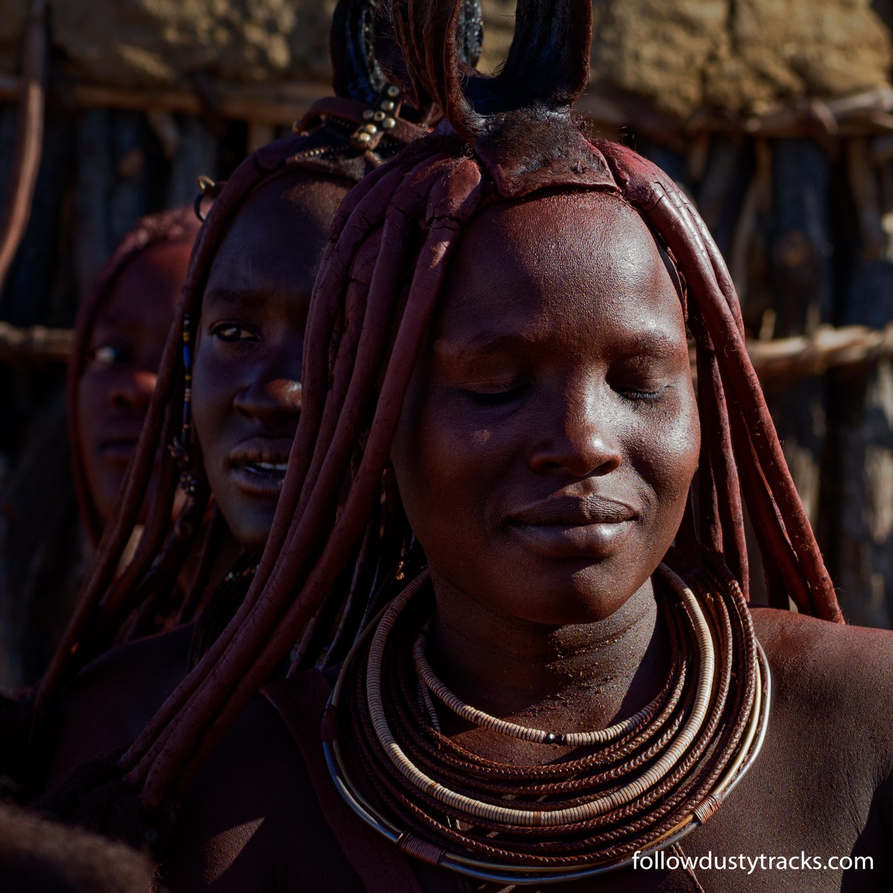
From Hobas we take the scenic route into Keetmanshoop to do a little shopping. The town is almost deserted and most shops are closed as it is the afternoon of Independence Day, 27 years since the country ceased being South West Africa, a protectorate of South Africa. We find one supermarket open and the staff are dressed in traditional clothes of the area with elaborate bright pink skirts or dresses.

From there we drive west along the highway toward the coast. We’re headed for the town of Luderitz but it’s too far to reach today so we call into a couple of places in search of a shaded camp site. It’s very hot and the sites have little or no shade so we keep driving until after 5.00pm when the worst of the heat has passed and we stop in a roadside rest stop at the top of a pass. The views are great and by dark the traffic has ceased so we have a peaceful night.

In the morning we make an early start so we can start our crossing of the Namib desert with the sun rising behind us. What a wonderful way to start the day. We reach the tiny town of Aus before breakfast but nothing is open so we eat at another rest stop just past the town. Before long we are entering the sperrgebiet, from here until we reach the outskirts of Luderitz more than 100 km away we are not allowed to leave the road. Rest stops with shelters provide the only shade and the small amount of vegetation we had been seeing disappears so the surrounding country is either long stretches of sand and sand dunes with distant hills or jagged collections of rocky mounds. It sounds bleak but it’s also beautiful in its own way.

The Road to Luderitz

Luderitz is a small town built within rocky outcrops on the edge of the Atlantic Ocean. It’s heritage is German, diamonds and seafood and apart from the drama of its location between the desert and the ocean it is well worth a visit to see the grand colonial buildings and the colourful art deco houses. After touring around the town to see the sights, not a long tour as the town is small, we search for a place with good coffee and find a delightful garden café opposite the waterfront which makes ok coffee, very good bread rolls and amazing baked cheesecake. Hunger pangs alleviated we drive to the lighthouse in front of the town which is built on a rocky outcrop and is surrounded by a camping area. It’s rocky, is exposed to the frequent strong winds and has little shade but apart from that the location is perfect.

We end up spending five nights here and while the wind became a little tiresome the area provides plenty of photographic opportunities including Flamingos, Gemsbok/Oryx and Springbok close to town, another lighthouse 22km away at Diaz Point, little bays along the peninsula south of town and lots of well preserved and colourful art nouveau buildings in the town. Fellow travellers Jared and Jen from the US arrived shortly after us and after comparing travel plans we realised we would be visiting a lot of the same places. They are also planning on spending three months in Namibia so our paths are bound to keep crossing. We join them to watch the sun set over the bay on a couple of evenings and to enjoy a meal at an excellent seafood restaurant in the town.

About 10km inland from Luderitz is the ghost town of Kolmanskop. This was the major company town for diamond mining until the 1950s when richer finds were discovered at Oranjemund and the headquarters were shifted and the town deserted. It is within the sperrgebiet but permits are easily arranged and it is a popular tourist destination in the area as well as offering numerous photographic opportunities. The usual permit allows entry only between 9.00am and 1.00pm but photographic permits provide access from sunrise to sunset. Naturally Paul is there before sunrise then returns to camp so we can both visit during the usual hours and he returns a third time for sunset shots very pleased with what he has seen and photographed during his visits.

An informative tour is included as part of the permit and then we wander on our own through buildings in various stages of decay with sand drifting in and around. In its heyday the town had a casino and bowling alley as well as a theatre for shows by visiting performers, including opera singers. Some of the houses are very grand although the view through the windows to the bleak desert outside would have provided a stark contrast to the opulence inside. Now the bright desert sunlight filters through broken slats on to the faded wallpaper and sandy floorboards.

Leaving Luderitz we fill our freezer with fish and squid from one of the seafood processing plants. We retrace our road through the Namib desert to Aus smiling at the sight of the still under construction railway line disappearing into a sand dune and reappearing a hundred metres later at the other side of the relentless shifting sand. Dozers are parked beside the road near large dunes to help in the never ending job of keeping the road clear. Once the railway is in use they will need to work doubly hard.

From Aus we turn north along some dusty tracks through wonderful scenery. The roads are far better than expected, occasional soft or rough patches but generally very easy going. Hills and mountains with vastly different colours surround us as we drive through the valley. Some are sand dunes and they range from deep orange to white and the rocky hills could be red, black, brown, pink or mauve.

We turn off the road into a ranch which offers camping and follow the track to the base of the hills. At the homestead we are directed to the camp site a few kilometres away. A young Dutch couple are already camped there but there is heaps of room so we soon set up near a shady tree and braai to enjoy the rest of the afternoon and evening. Jared and Jen arrive soon after us and claim the next tree before joining us to share the braai and to watch the colours change in the wide open view in front of us and then the sky fill with stars.

Sunrise at Namtib

The light in the morning is wonderful and as the hills behind us block the early morning sun the temperature remains mild longer than usual so we are in no hurry to get back on the road. When we eventually make a move we continue or journey through the beautiful valley. After a reasonably long, for us, drive we reach Sesriem where we hope to spend a few nights. We have been told the campsite in the national park must be pre-booked as it is very popular but we are lucky enough to get one of two available sites. Lots of the sites have good shade but ours is pretty bleak with just a small tree but we’re not planning on spending much time at the camp and we are just happy to have got a site at all. Our tree does have a large Social Weavers nest in it. These can vary in size and the largest are conglomerations of hundreds of nests in one giant mass which looks somewhat like thatching.

Weaver Bird Nest at Sesriem

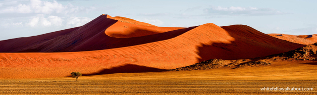
From the camp we can drive to Sossusvlei which is right in the Namib desert with massive dunes which display their most intense colours at sunrise and sunset. The drive takes almost an hour and the internal control gate is not opened until 6.00am, an hour before the sun rises but if we had to camp outside the park we would not be able to start the drive until 7.00am and we would miss the most spectacular part of the day.

We’re in the park for three nights and the days fall into a pattern. Up in the dark at 5.30am and lining up at the control gate by 5.50. A quick drive for 60km on the paved road to the 2wd car park then a much slower 5km drive through deep soft sand to the final car park. Photography and a stroll to enjoy the colours and views and quietness of the desert calm fill in the next hour or so then we sit in the shade for a leisurely breakfast and coffee loving the atmosphere of this amazing place. We had planned on some walking to a couple of other vleis (low lying flat areas sometimes marshy but in these cases almost always dry and surrounded by dunes) but by the time we have had our breakfast the day is far too hot for us to enjoy a walk.

By the time we return to camp the morning has nearly finished and as we plan to go out again we have just a few hours to eat lunch, take a swim in the pool and to do some reading or download photos before we get ready for our next outing. Our evening destinations include some of the dunes on the road out to Sossusvlei or the lookout closest to camp near Elim Dune. After we have watched the sun set, around 7.00pm, we have an hour to watch the remaining light and to get back to camp before the control gate is closed. Then it’s time to prepare dinner before we fall into bed so we can repeat the same thing the next day.

After a wonderful but exhausting three days we leave Sesriem to start our journey towards Windhoek, the capital of Namibia. We’re not planning on arriving there for four or five days so we plan to stop in a couple of places along the way. We call into several camping and accommodation places but aren’t happy with any of them so we stop for a break in a cafe in one of the tiny settlements along the way.

It’s home week when we walk into the café. Two German girls we had been speaking to at Sesriem greet us from one table and we join Jared and Jen at the next table. They have also been looking for a spot to camp on the way to Windhoek so we join forces in our search. Two more camps are rated unsatisfactory and then a third of the way up the very steep Spreetshoogte Pass we turn off the road and find three sites carved out of the hillside. Two are camp sites with their own private shower and toilet with a verandah in front and the other is a cabin with beds for four. The view is outstanding and we’re keen to stay but wondering how we get in touch with the owner when he drives in to greet us.

Hugh has two ranches on the valley floor and saw us drive in. He shows us how everything operates, provides us with some extra firewood and takes orders for some braai packs to be delivered the next day. When they arrive they are accompanied by some complimentary corn bread Hugh’s wife baked, delicious. Life on the edge is wonderful, the views are mesmerising and the verandah provides shade, there is water and our solar panels provide power so we’re all happy to stay five nights before we need to head into the city. Paul manages a couple of days of photo processing but then fridge and battery problems consume most of the power we generate so he has to restrict his computer use.

Spreetshoogte, Southern Namibia

One of our major activities is cricket. Chasing huge crickets away, bowling stones at them and jumping when they crawl on us. They’re always around at this time of the year and none of us have ever seen any as large or relentless as these. Our flip flops make good cricket bats and we send them flying to clear our work and sitting areas.

Finally we’re ready to head into the city. The rest of the pass has to be climbed and we are concerned about our towing ability. The land cruiser will get anywhere we want but the power is low so on gradients as steep as these we need low range 4wd. That’s not usually a problem but they have paved the road up the pass and there are a couple of very tight turns and it is not good to use 4wd in these circumstances. Jared offers to tow our trailer up and save us a 100km detour so we travel together across to the highway and into Windhoek.

We’re all in the Elisenheim Guest Farm camping area 10km north of the city and staying for a week. We’re having more problems with our gear box which are being fixed by Toyota (under warranty we hope) as well as other chores and Jared and Jen also have work to do before we head back out of town. In the meantime we’re enjoying the peace of the country mixed with comfort of an excellent restaurant and the early morning wake up of the naughty Baboons. We’re not sure yet when we’ll get the car back but we’ll keep you posted on our future adventures.

PS, we picked up the car late Wednesday afternoon and left Windhoek Thursday morning so we could get out of town before Easter. We’re heading for the coast at Swakopmund but it will be very busy over Easter so we’re detouring through some of the mountains slightly north of there on our way. Hoping you are all having or have had a lovely holiday break.